


Seoul, South Korea – The Korea Meteorological Administration (KMA) announced on Tuesday that it is expanding its road weather hazard information service, which provides real-time updates on road conditions to drivers, to an additional five highways. This expansion aims to enhance road safety and improve traffic management.
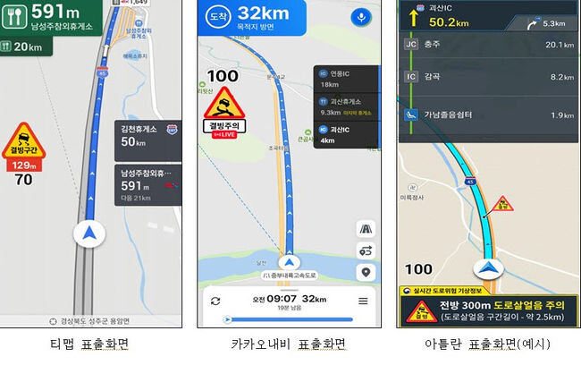
The service, which is now available on seven highways, delivers critical information such as the likelihood of black ice and reduced visibility to drivers through popular navigation apps like T Map, KakaoNavi, and Atlantes, as well as variable message signs (VMS) along highways. Black ice information is provided during the winter road management period (November 15 to March 15), while visibility hazard information is available year-round.
The newly added highways include the Gyeongbu, Jungang, Honam, Yeongdong, and Tongyeong-Daejeon/Jungbu lines, which are known for their heavy traffic and long distances. With this expansion, the service now covers over 50% of the 31 national highways, totaling 2,109 kilometers out of 4,100 kilometers.
The KMA has been collaborating with the Ministry of Land, Infrastructure and Transport and the Korea Expressway Corporation to establish a road weather observation network by jointly utilizing the highways’ power, communication, and facilities. By 2026, the agency plans to complete the network on all 31 major highways and gradually expand the service.
"We expect this service expansion to contribute to preventing traffic accidents and ensuring safer driving for the public," said Jang Dong-eon, head of the KMA. "We will continue to provide effective weather information to protect the lives and property of our citizens."
[Copyright (c) Global Economic Times. All Rights Reserved.]