


Bucheon City, Gyeonggi Province, will fully promote the 2025 cadastral resurvey project to protect the property rights of land owners and realize smart cadastral administration based on digital technology. The city announced on the 7th that it will conduct cadastral resurveys for a total of 169 parcels spanning 172,052㎡ in the Dodang 1, Okgil 3, and Yeowol three zones.
The cadastral resurvey project is a national policy initiative targeting areas where cadastral records and actual land use have been inconsistent for a long time. It aims to create new cadastral maps that align with the current boundaries using cutting-edge surveying technology and to build accurate digital cadastral information. This is significant as it resolves boundary disputes between landowners, supports efficient land management and utilization, and ultimately enables the provision of various administrative services based on digital cadastral data.
Bucheon City has been thoroughly preparing for the successful implementation of this cadastral resurvey project from the preliminary stages. It has established implementation plans for the project zones and actively engaged in communication efforts, such as holding online resident briefing sessions to help landowners understand the project. Currently, the city is in the process of securing consent from more than two-thirds of the landowners for the project, which is expected to be a crucial driving force for its progress.
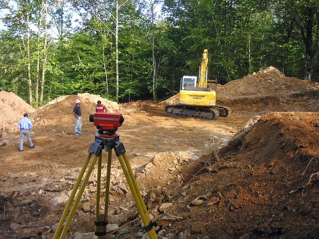
The cadastral surveying will be carried out by the Incheon-Gyeonggi Nambu Regional Headquarters of LX Korea Land and Geospatial Informatix Corporation, a public institution under the Ministry of Land, Infrastructure and Transport, as the designated responsible agency, ensuring professionalism and reliability. The surveying process will involve precisely identifying not only past cadastral maps but also actual occupancy conditions such as buildings, fences, and roads to establish new boundaries. In particular, temporary boundary markers will be placed on-site during the survey so that landowners can directly check their land boundaries.
The core of this cadastral resurvey project is the active participation and cooperation of landowners. The newly established boundaries will be finalized through sufficient consultation between landowners based on the temporary boundary markers indicated during the survey. Accordingly, Bucheon City plans to individually notify landowners in the project zones of the surveying schedule for each parcel and requests for their presence. If it is difficult to be present during the notified period, arrangements can be made by phone. Accurately verifying one's land boundaries and expressing opinions is a very important process for preventing future boundary disputes and protecting property rights.
An official from Bucheon City emphasized, "The cadastral resurvey project is not just about replacing old cadastral maps, but a crucial project to build accurate digital cadastral data based on actual boundaries." They added, "The active participation of landowners is key to establishing accurate and fair boundaries," and stated, "We will do our best to successfully complete the project by reflecting the valuable opinions of landowners as much as possible and contribute to protecting the property rights and enhancing the convenience of land use for citizens."
The cadastral resurvey project is expected to contribute to improving the efficiency of land management in the long term, securing the transparency of real estate transactions, and promoting the development of various spatial information-based industries. Bucheon City's 추진 of this project is an important step towards meeting these national goals and providing citizens with more accurate and reliable cadastral information. In the future, Bucheon City plans to successfully complete the cadastral resurvey project through continuous communication and cooperation with landowners and build an advanced cadastral administration system suitable for the digital age.
[Copyright (c) Global Economic Times. All Rights Reserved.]